• Skip to main content
Berkshire Links

Berkshire Links

  • Book rooms
  • Berkshires towns
  • Berkshires dispensaries
  • Berkshires parks
  • Bob Dylan
You are here: Home » Towns and cities

Berkshires towns homepages

How to get to the Berkshires

Here are inks for local and regional public transportation depots and stops, plus where to get Peter Pan bus and Amtrak train schedules and tickets: how to get to the Berkshires.

Adams, MA

Adams-McKinley-Statue
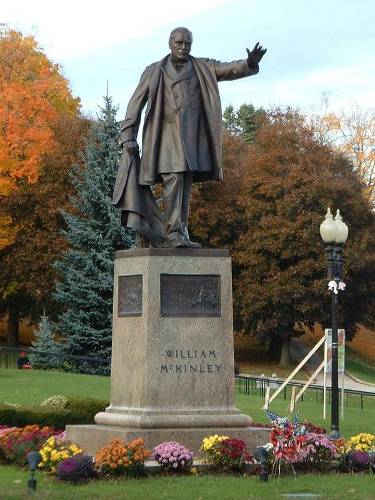
The town of Adams, located 15 miles north of Pittsfield on Rt. 8, is noted as the birthplace in 1820 of Susan B. Anthony, a descendent of the Quakers who settled the area in the 18th century. Adams is situated along the Hoosac River, with the Hoosac Range to the east and the summit of the state’s highest peak, Mt. Greylock, immediately east of town. A statue of President William McKinley is located at McKinley Square at the intersection of Columbia & Maple Streets, Adams, MA. The base is surrounded with three scenes of his actions, in the Civil War, in Congress, and as President, with the fourth side bearing a quote from the Pan-American Exposition: “Let us remember that our interest is in concord not conflict, and that our real eminence rests in the victories of peace, not of war.”

Quaker Meeting House

Adams, Mass. Quaker MeetinghouseThe Quaker Meeting House, built in 1782, is open to visitors on Sundays between Memorial Day and Labor Day. Adams celebrates the legacy of Susan B. Anthony with a summer festival; the Adams Agricultural Fair is held every August and the annual Greylock Ramble attracts as many as 1,000 hikers to the mountain on Columbus Day. (Photo credit)

  • Town Hall: 8 Park St. 01220; 413-743-8320
  • Population: 8,809
  • Settled by/Inc’d: Rhode Island Quakers/1776
  • Named for: Samuel Adams,
    Revolutionary
  • Elevation: 799′
  • Adams, MA town website

[mappress mapid=”81″]

Adams, MA once known as the East Hoosuk Plantation

First surveyed in 1739 and known as the East Hoosuk Plantation, Adams was incorporated in 1778 and included present-day North Adams until 1878. A National Register Historic District of 70 Victorian homes recalls the days when textile industry drove Adams’ economy, as does a statue of President William McKinley whose policies benefited the domestic textile industry and who was a friend of the Plunkett brothers, founders of the Berkshire Cotton Mfg. Co..

Alford, Mass.

Alford, MA has had a mill for its grist since 1763, when the town had about twenty fewer residents than it does today! During the first half of the 19th century, there were a dozen marble quarries in Alford, but when the railroads were laid elsewhere, they became unprofitable. Today, Alford is the quintessential bedroom community: no stores, no motels or hotels, and not a single gas station.

The state line at Route 71, with a Knox Trail marker beside the road sign
By ToddC4176 at en.wikipedia, CC BY-SA 3.0, Link

“Old-fashioned, easygoing Alford …”

“Old-fashioned, easygoing Alford is not so far off the main traveled routes through Berkshire that it is a backwoods village, nor so close to have taken on the frills of a summer resort. The scattered houses, white church, and little school are built on a narrow shelf of land extending a quarter of a mile along the eastern side of the platter-shaped valley.

“To the south is Mt. Everett, one of the highest mountains in Berkshire, 2,624 feet above sea level. The western slopes of the valley are checkered with meadow and woodlots, mounting toward an unbroken line of trees against the sky.” (The Berkshire Hills, by Federal Writers’ Project, © 1939, Berkshire Hills Conference, Inc.)

Alford, MA facts:

  • Town Hall: 5 Alford Center Rd.
  • Phone: (413) 528-4536
  • Population: 399
  • Settled/Inc’d: 1740/1773
  • Named for: Col. John Alford of Charlestown
  • Elevation: 960′
  • Alford.org

[mappress mapid=”82″]

Becket, Mass.

Becket Arts Center, Becket, Mass.The world famous Jacob’s Pillow Dance Festival is located in Becket, an upland town that once supported a prosperous lumber industry and now is noted for its many summer camps and second homes. The West Branch of the Westfield River, which forms part of the northern boundary of Becket, is highly regarded by trout anglers. [retweet]

“In 1927, the Ballou Reservoir burst its earthen bank and poured a 25 foot wall of water down the narrow valley…and the settlement was nearly wiped out. The town’s principal industry, a silk mill, was swept away; houses and shops floated downstream with the flotsam and the debris. This disaster marked the end of Becket’s era of industrialism.” [The Berkshire Hills, by Federal Writers’ Project, © 1939, Berkshire Hills Conference, Inc.]

Becket Lore:

Paul Revere and Johhny Appleseed – The bell in the Congregational Church (1780) was made by Paul Revere. Johnny Appleseed hiked to the top of Jacob’s Ladder around 1801.

In 1975, Bob Dylan & The Rolling Thunder Revue (including Joan Baez, Arlo Guthrie, Allen Ginsberg, Ramblin’ Jack Elliott) spent the day at Mama Frasca’s Dream Away Lodge in Becket. Bob Dylan and the Rolling Thunder Revue spent the day at the Mama Frasca’s Dream Away Lodge in Becket, MA.

How Becket got named

The original “Beckett” for which the town of Becket was named, is an estate or “tithing” which once belonged to the Admiral Lord Barrington (as in “Great Barrington, MA). It is located at the southern tip of Berkshire, England, about five miles east of the important railroad town of Swindon.

Sir Francis Bernard, the Royal Governor of Massachusetts in 1765, was a close friend of Lord Barrington and was himself a native of Berkshire. It is said that he enjoyed many a happy restful holiday in the beautiful surroundings of Beckett, and that these pleasant memories influenced him in 1765 to give the name Becket to Township Number Four when he approved its incorporation.

The origin of the name “Beckett” is still a puzzle. In early days it had been spelled “Becote” and is believed to be of Norman French derivation. There seems to be no known connection with the name or family of the famous Archbishop of Canterbury, Thomas A’Becket. The name always went with the property, long before it was granted to Lord Barrington as part of his perquisites when he was raised to peerage.

Becket, MA facts:

  • Town Hall: 557 Main St.
  • Phone: (413) 623-8934
  • Population: 1,755
  • Settled/Inc’d: 1740/1765
  • Elevation: 1,207′
  • Town website: townofbecket.org/

[mappress mapid=”85″]

Cheshire, Mass

The Berkshires town of Cheshire, Mass. boasts a 500 acre lake, spectacular views from Stafford Hill, and one of the most unusual monuments anywhere, which celebrates the 1,235 pound cheese presented to President Jefferson by Cheshire farmers. Cheshire is located within the valley of the Hoosic River, and is the site of a dammed reservoir on the river. To the west, parts of Mount Greylock State Reservation take up sections of town, and includes a section of the auto road.

Ashuwillticook Rail Trail, Cheshire Reservoir, Cheshire, MA

To the southeast, North Mountain peaks just outside town limits before descending to the valley. The Appalachian Trail crosses through the center of town, heading from North Mountain to Mount Greylock. The southern foothils of the Hoosac Range make up much of the eastern side of town, and much of the land is dotted with sections of the Chalet and Stafford Hill Wildlife Management Areas. Several other brooks feed into the river along the way.

“The Great Cheese symbolized Cheshire’s satisfaction with the election of Thomas Jefferson to the Presidency in 1800. The idea of creating this monster among edibles was put forth by a baptist clergyman of Cheshire, Elder John Leland. A friend of Jefferson, he thought the town should send the new executive a testimonial of esteem.” (The Berkshire Hills, by Federal Writers’ Project, © 1939, Berkshire Hills Conference, Inc.)

The popular Ashuwillticook Rail Trail runs along the shore of Cheshire reservoir, and many Appalachian Trail through-hikers receive mail and provisions at the village post office.

Cheshire, MA facts:

  • Town Hall: 80 Church St.
  • Phone: (413)743-1690
  • Population: 3,401
  • Settled/Inc’d: 1766
  • Named for: Cheshire, England
  • Elevation: 945′

[mappress mapid=”194″]

Clarksburg, Mass

Clarksburg, Mass. Town Hall; photo by Wikipedia user ToddC4176.

The Berkshire county town of Clarksburg, located on the scenic and historic Mohawk Trail, combines all of the benefits of rural living with an excellent elementary school (K-8), sufficient land available for development, and direct access to the urban amenities of nearby North Adams, Mass. The town recently created three areas for industrial development and intends to aggressively promote them to relieve the present basically residential tax burden.

Captain Matthew Ketchum, Colonel William Bullock, and Nicholas Clark are credited with having originally settled the eventual township in 1769, and the latter ultimately became Clarksburg’s namesake. The town began as a mostly agrarian community, with mills springing up along the waterways in the nineteenth century. The major mills were one to make cashmere, and several mills supplied gunpowder during the Civil War. However, the industry was stopped by the town after one of the mills exploded in 1869. (from wikipedia.)

Clarksburg, MA facts:

  • Town Hall: 111 River Rd.
  • Phone: (413) 663-7940
  • Population: 1,686
  • Settled/Inc’d: Capt. Ketchum, N. Clark/1769
  • Named for: Nicholas Clark’s family
  • Elevation: 1,000′

[mappress mapid=”96″]

Dalton, Mass.

East branch of the Housatonic River at Dalton, Mass.; photo by wikipedia user:Faolin42

Situated just east of Pittsfield on Rt. 9, the Berkshire county town of Dalton, Mass. has great recreational and athletic resources, including Wahconah Falls State Park. In 1801, Zenas Crane, Henry Wiswall and John Willard set up a paper mill along the river which, by 1844, had begun producing bank note paper, which was purchased by banks all the way to Boston. The company, Crane & Co., still is the largest employer in town, making paper products, stationery, and, since 1873, has been the only supplier for the Federal Reserve Note, the United States’ paper money.

Dalton, MA facts:

  • Town Hall: 462 Main St.
  • Phone: (413) 684-6111
  • Population: 6,892
  • Settled/Inc’d: 1755/1784
  • Named for: Tristam Dalton/MA-Speaker of House
  • Elevation: 1199′

[mappress mapid=”97″]

Egremont, Mass

The Berkshire county town of Egremont, Mass. comprising North and South villages in the Taconic Valley, is noted for its many antiques shops, charming inns, and superb restaurants. The Catamount Ski Area is located in South Egremont, making the area’s tourism industry a year-round enterprise. Egremont was settled by Dutch farmers in 1730 and once was a stagecoach stop on the Albany-Hartford road.

note from Egremont, UK – “The original and real Egremont is here in Cumbria in north west England named after the pointed hill (aigre mont) on which the Normans built a substantial sandstone castle in the twelfth century. We are only five miles from Whitehaven where George Washington’s Grandmother is buried.

Thought you might find this information useful. My name is Tom Higgins and I’ve lived here all my life. If you would like to know more about my town and the most beautiful county in England e-mail Tom Higgins and I will gladly provide whatever I possibly can. Awreet Marras tara fer noo !”

Egremont, MA facts:

  • Town Hall: P.O. Box 368
  • Phone: (413) 528-0182
  • Population: 1,345
  • Settled/Inc’d: 1760
  • Named for: Charles Windham, Earl of Egremont
  • Elevation: 740′
  • Demographic data: state.ma.us/cc/egremont.html

[mappress mapid=”95″]

Florida, MA

Florida, Mass. on the Mohawk Trail in the Berkshires; Photo by Jozef Nagy

Florida, Mass. is a small town in the Berkshires located along the Mohawk Trail high up in the foothills of the Green Mountain Range, is the site of one of the great engineering feats of the 19th century – the Hoosac Tunnel. The Florida section of the Deerfield River is very wide, from 25′ to 150′, and offers the best brown, rainbow, and brook trout fishing in the Berkshires.

“In 1805, when the town was incorporated, there was talk of the United States purchasing the territory of Florida from Spain. The new village among the mountains chose the name of the flat, tropical region of palms and pelicans. Perhaps an overdeveloped sense of humor on the part of the town fathers contributed to the extraordinary choice.” (The Berkshire Hills, by Federal Writers’ Project, © 1939, Berkshire Hills Conference, Inc.)

Florida, MA facts:

  • Town Hall: 379 Mohawk Trail, Drury, MA 01343
  • Phone: (413) 662-2448
  • Population: 676
  • Settled/Inc’d: 1783/1805
  • Named for: Florida (see note below)
  • Elevation: 2,180′
  • Town website: townofflorida.org

[mappress mapid=”94″]

Great Barrington, MA

Mahaiwe Performing Arts Center vintage images

Great Barrington, Mass maintains a small town charm and character while serving as the commercial hub of south Berkshire county. A unique array of fine restaurants anchors the town’s tourism industry today, while Gt. Barrington’s history includes events and persons of world stature. Great Barrington was the site of the first organized resistence to British rule in the colonies, was the birthplace of scholar and political leader W.E.B. DuBois (a founder of the NAACP), and, as the home of inventor William Stanley, was the first municipality with electric streetlights. Cultural center of Gt. Barrington is the Mahaiwe Performing Arts Center.
Gt. Barrington native W.E.B. DuBois

Great Barrington, Mass facts:

  • Town Hall: 334 Main St.
  • Phone: (413) 528-3140
  • Population: 7,527
  • Settled/Inc’d: 1726/1761
  • Named for: Viscount Barrington
  • Elevation: 710′

[mappress mapid=”68″]

Hancock, MA

Hancock, MA Town Hall, October 2009; photo by John Phelan

The town of Hancock in the Berkshires, was re-named for John Hancock in 1776, the year of its incorporation, from Plantation of Jericho, as it was called by the original settlers in 1762. Hancock Shaker Village was established there in 1790, becoming a thriving Shaker community before the movement’s mid-19th century demise. In 1960, the Hancock community was closed by the Shaker Central Ministry, and the next year Hancock Shaker Village, a non-profit museum was opened; it was added to the National Register of Historic Places in 1968.

Points of interest in Hancock include: Hancock Shaker Village, Jiminy Peak, the state’s largest ski area, time-share mecca Vacation Village At Berkshires, a barn museum, a campground, a nudist camp, and twenty-four known and catalogued cemeteries.

Hancock, MA facts and map:

  • Phone: (413) 738-5225
  • Population: 721
  • Settled/Inc’d: 1767/1776
  • Named for: John Hancock
  • Elevation: 1020′

[mappress mapid=”61″]

  • Go to page 1
  • Go to page 2
  • Go to page 3
  • Go to page 4
  • Go to Next Page »
  • Piretti Tennis and Sports Surfacing
  • Lenox rentals, SunnyBank Apartments

© 2001–2021 Dave Read WordPress by ReadWebco